

India’s 27-name map move, China’s Zangnan claim, and the deeper contest over strategic presence, sovereignty and the frontier
On August 7, India did something that, on the surface, might have looked misleadingly simple. The Government of India officially designated 27 places and geographical features in Arunachal Pradesh using standard names on official Survey of India maps. The government said that the immediate purpose was to facilitate accurate identification of the locations and improve public awareness. The list includes several land areas, four passes, a lake and a memorial. But the question is not really why India named 27 places. It’s something deeper than this, let’s analyse it.
The most important contemporary question is, why would the naming of places in its own state on a map by one country elicit such a pronounced reaction from another country?
And that question takes us far beyond this geopolitical periphery of mere cartography. It takes us into one of Asia’s longest-running territorial disputes until today.
The map is not the territory, that’s certainly true, but does it become “political?” India did not physically move its international border on August 7. Neither did it acquire 27 new territories.
China, however, saw something very different and reacted. And this is where the change of names became a headline. On August 10, Chinese Foreign Ministry spokesperson Guo Jiakun reiterated, China’s position that Zangnan was a Chinese territory and described India’s attempt to replace names used by China with Indian “standard names” as “illegal, null and void.” He said that this move would not alter China’s claim on the region.
That response reveals the entire real issue. A place name may appear completely harmless. But when a government on multiple occasions places a particular name on its official maps, administrative documents and diplomatic statements, it can become a way of conveying a subtle message. Like, this is how we identify our place and understand the territory. That is why maps are not always politically neutral. They can communicate territorial boundaries, local and national identity, administrative authority and sovereignty. So what is happening between India and China can plausible be referred to as a cartographic contest or, in some commentary, a “map war.”
But the phrase needs to be comprehended correctly. There is no actual war being fought over maps. The map is better understood as a political arena in which the two countries solidify competing territorial narratives. In order to comprehend why China objected, one must first interpret what Arunachal Pradesh is.
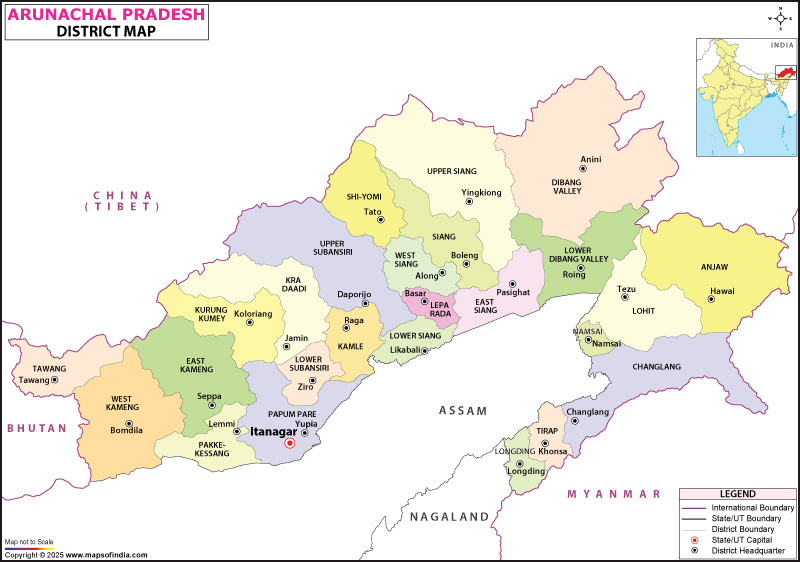
Arunachal Pradesh is India’s northeasternmost state. It borders China to the north, Bhutan to the west, Myanmar to the east, and Assam and Nagaland to the south.
Arunachal Pradesh is an indian state, but China continues to lay claims on a large part of it. China’s official position is not that Arunachal Pradesh is merely a region whose name India has got wrong. Beijing rejects the Indian designation itself and says the territory belongs to China. In April 2026, Chinese Foreign Ministry spokesperson Guo Jiakun said China had the sovereign right to issue standard names for places in what it calls Zangnan. Thus, the dispute over names is only the visible layer of a much deeper fundamental disagreement.
Who has sovereignty over Arunachal Pradesh?
India’s answer is decisive and firm : India, …. meanwhile China’s answer is equally unequivocal: China claims it as Zangnan. The historical roots of the eastern India-China boundary dispute goes back to 1914, when British India and Tibet negotiated a boundary during the Simla Convention. The resulting McMahon Line is regarded by India as the legitimate boundary in the eastern sector. But China clearly rejects that interpretation. Beijing has argued that Tibet did not possess the independent authority to conclude such a boundary agreement with British India and that China did not accept the resulting arrangement.
Longju: why one of the 27 names matters
The choice of locations is also important for development. Chinese forces clashed with Indian troops at an Indian post at Longju in 1959, making it one of the most important early flashpoints that preceded the Indo-China war of 1962. China’s naming exercises in Arunachal Pradesh did not begin in 2026. They are part of a pattern that has continued for several years, so India’s August action cannot be understood in mere isolation. This is another reason the August action cannot be understood in complete isolation. China has frequently issued its own names for locations in Arunachal Pradesh. The sequence has included naming exercises in 2017, 2021, 2023, 2024, 2025 and 2026. In April 2026, China announced another batch involving 23 locations. Chinese officials have explicitly defended the country’s right to name places in what Beijing calls Zangnan. But India has continuously rejected these Chinese naming exercises.
So does naming a place change sovereignty?
No. This is perhaps the most important point in the entire story. An Indian name on an Indian map does not, by itself, create Indian sovereignty. Likewise, a Chinese name on a Chinese map does not, by itself, create Chinese sovereignty.
So India’s August 7 action should not be strictly described as India suddenly “acquiring” 27 territories. It is better understood as a cartographic assertion of India’s existing territorial position. But a “symbolic” representation does not mean it is “meaningless.”
The bigger question: who actually controls the ground?
This is where the concern becomes considerably more convoluted. A country can claim territory without controlling it. And a country can also control a territory that another country claims. Both are quite different contexts.
For Arunachal Pradesh as a whole:
It is defacto and de-jure an Indian State. But China claims it.
The emergence of the 60-kilometre controversy
While the map controversy was unfolding, another story has grasped immediate attention from the Arunachal frontier. Reports and viral videos claimed that Chinese forces had moved 60 kilometres into Arunachal Pradesh and had in practice captured Indian territory or villages.
But the Union Minister Kiren Rijiju has completely rejected this claim on August 19. He said it was wrong to describe the situation as China having entered 60 km into India and captured an Indian village. At the same time, however, he has conceded to the fact that there is a genuine problem concerning the boundary’s delineation and said concerns raised by villagers were valid and quite authentic.
So what does “not demarcated” actually mean?
This is where many social-media discussions have become partially perplexed.
Boundary
The line separating two territories.
Delineation
Defining where that boundary runs, particularly through maps and agreements.
Demarcation
Physically marking the agreed boundary on the ground — for example through boundary pillars or other markers.
Under ideal conditions, the process looks something like:
Negotiation → agreement → delineation → physical demarcation
The LAC is not the same thing as an international border. The Line of Actual Control (LAC) is the practical benchmark kind of a line deliberately separating areas controlled by India and China. But the two countries do not mutually agree on the entire alignment of the LAC. That creates what are often termed as differing perceptions. The absence of completely adjudicated international boundary, demarcation therefore creates a particularly sensitive environment for both the respective nations.
And this is not simply theoretical. On August 6, India and China held the 36th Working Mechanism for Consultation and Coordination on India-China Border Affairs, discussing boundary delimitation, border management and mechanisms to prevent errors in understanding and miscalculations along the LAC. In other very simple words, we can interpret this as :
The boundary question is still being negotiated.
But what about the people living there?
In June 2026, the Nah Welfare Society (NWS) purported that the People’s Liberation Army had expanded its presence near Taksing in Upper Subansiri, naming locations encompassing Oying, Paniar, Marpan, Portrang and Tingdingtang and alleging construction of military infrastructure.
But the Indian Army repudiated those allegations, referring to reports of recent Chinese encroachment and camps as “incorrect and without basis.” Arunachal Pradesh authorities afterwards also dismissed the claims, while local political voices called for verification. “A local community organisation has allegedly stated that Chinese expansion near five locations around Taksing; but the Indian Army has completely denied the allegations, and the claims remain variably contested.”
Are people in remote Arunachal frontier communities sufficiently connected to the Indian state?
Why does a Chinese mobile signal not mean China has taken the village?
Reports and some viral videos from Arunachal have documented Chinese mobile signals reaching Indian border areas for years. A 2018 report from The Arunachal Times, for example, described villagers receiving messages from Chinese mobile networks, with a source saying signals could extend kilometres into the Indian side. But a mobile signal crossing a mountain does not recognise a political boundary. But the underlying problem is still very legitimate. And it does matter.
If an Indian citizen living in an Indian border village receives a stronger foreign network than an Indian one, that raises questions about connectivity, infrastructure and state presence. And those questions matter strategically. This is where the roads and villages enter the story. A border is not merely preserved only by soldiers. A functioning frontier also requires: roads; telecommunications; electricity; schools; healthcare; economic opportunities; government services; civilian settlement; security infrastructure.
If a remote border village has no credible road, poor connectivity, limited employment and inadequate public services, residents may eventually be forced to migrate elsewhere, or maybe to a nearby city in order to have access to their basic amenities.
That does not automatically relocate sovereignty to another country. But it can definitely make the state’s civilian presence weaker day by day. And that is why the border development becomes a strategic issue.
The Vibrant Villages Programme
India’s Vibrant Villages Programme is particularly relevant here. The programme was launched in 2023 to develop selected villages along India’s northern border. Its measures include roads, village infrastructure, energy, telecommunications, livelihoods, tourism, healthcare and education, with the explicit objective of creating incentives for people to remain in these villages. As of July 2026, 662 villages had been correctly recognised for priority development under VVP-I, including 455 in Arunachal Pradesh. The government reported hundreds of projects covering roads, 4G connectivity, drinking water, electricity, health and school infrastructure.
So when we say:
“A border is protected not only by soldiers but also by roads, people and administration,”
We simply do not mean that civilians are soldiers. Rather it illustrates that a functioning civilian population creates continuous human and administrative presence in a frontier region.
Tawang adds another layer to the existing dispute because of its strategic location and its deep spiritual connection to Tibetan Buddhism. The Tawang Monastery is one of the most crucial Tibetan Buddhist institutions outside Tibet, thereby giving the region a huge significance beyond its ordinary geography. But this religious dimension should not obscure the overlying pivotal Issue here; the unresolved territorial dispute between both the nations.
There is a superficial similarity:
One country administers a territory while another country claims it.
But Arunachal Pradesh should not simply be equated with Pakistan-occupied Kashmir or the broader Kashmir dispute. The historical circumstances, legal frameworks, wars, lines of control and patterns of administration are totally different.
There is, however, one useful concept that can be borrowed from the study of territorial disputes. That distinction is much more useful than saying Arunachal is “becoming POK.”
So could China continue claiming Arunachal?
Absolutely. China already has been doing this. And there is no automatic rule in international relations that forces a state to abandon a territorial claim simply because another state administers the territory.
Not all battles are fought only on the ground. They do not always require soldiers immediately entering a battlefield, or conflict in the air or on the water. Sometimes, the contest takes place through several layers of diplomacy, maps, names, infrastructure and the ability of people to remain connected to the state that they actually belong to. And that is why the real battle may not happen only on the ground. The question, therefore, is not simply whether China is actually gaining control over Arunachal Pradesh. It is whether India and China can continue managing a disputed frontier without allowing conflicting claims and facts on the ground to make a future settlement even harder. Because beyond the maps and geopolitical arguments, there is a deeply human dimension to this dispute. In a video circulating online, a young child from Arunachal Pradesh was heard saying, “हमको चाइनीज मत बुलाओ, हम एक इंडियन हैं” , “Please don’t call me Chinese; I am an Indian.” That sentence perhaps captures what is ultimately at stake: not just territory on a map, but the Indian identity and sense of belongingness of the people who live there.
Article by Sruti Bhaumik and Edited by The Wonk Team